Investigating the Impact of Different Management Practices on the Chemistry and Physical Properties of Sapelo Island’s Soil
by Riya Sachdeva, Ecology
This study investigates the variation in color, texture, pH and nitrate content of the Sapelo Island soils influenced by various human impacts and management practices. It investigates 10 different sites over 3 levels of impact around the Southern end of the island. While there were no significant results from this study, there were a few identifiable trends that can inform further study. The color was primarily 10YR2/1, not straying far from the dark color except for the septic site. The textures were mostly sandy and well drained, with a few sites containing loam mixtures as well. The pH ranged from 4.96 to 7.11, with the general trend of high human impact raising the pH closer to 7 and the low impact moving closer to 5. The nitrate content ranged from 0 mg/L to 8 mg/L and had very little correlation with the impact levels. This was most likely due to procedural errors and time constraints. There is evidence that human impacts influence soil properties on Sapelo Island, but the nature and source of these influences requires further investigation.
soil, Sapelo Island, ecology, soil science, Georgia, Barrier Islands
Introduction
Soil is the foundational substance that influences most ecosystems, forming the land and supporting the primary producers. It is also uniquely tied to the barrier islands as their soil bases shift over the eons, causing islands to migrate down the coast. While Sapelo Island has been lauded as a pristine location to conduct research, humans have had a relationship with the land for thousands of years, from indigenous settlements to agriculture to research. Indigenous people lived on the island before colonization, then post-colonial Sapelo saw plantations and dairy farms until the 1950s, when the UGA Marine Institute was established (Chalmers 1977). Human impacts on erosion, pH, and nutrient content of soil have been well studied, especially regarding urbanization and agriculture. For example, cotton farming on Georgia soil caused severe erosion and A horizon loss (United States Department of Agriculture 2023). The land’s long history of agriculture and human use has most likely resulted in alterations to the soil chemistry and physical properties. There are few places in the world that have experienced the same cycles of constructive and destructive agriculture, rewilding/restoration alongside a remote research institute.
Coastal plain soils are usually sandy and well drained spodosols part of the Ona and St. John’s series (United States Department of Agriculture 2023). These soils are usually high in aluminum content and organic matter, making them relatively acidic. They are often sandy, dark, and coarse-grained.
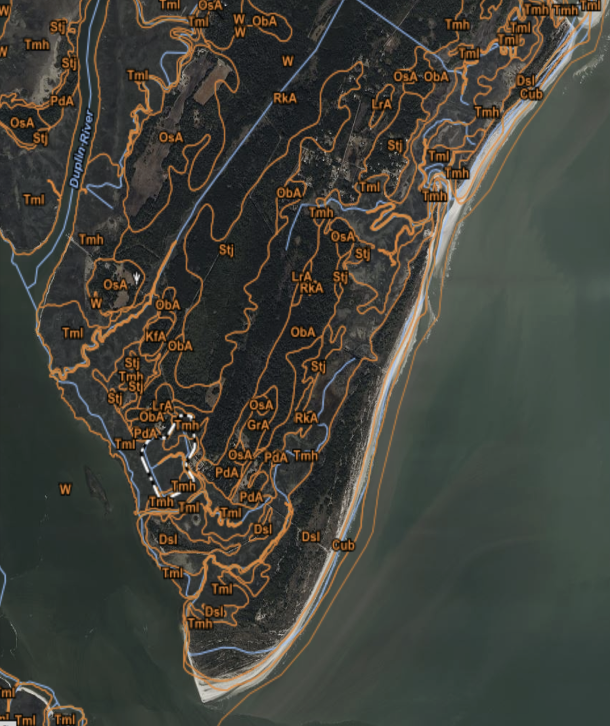
Figure 1. A soil map of the Southern tip of Sapelo Island
However, the agricultural history of Sapelo Island affects the soil as well. Healthy crops usually require a pH of 6.5-7 and high nutrient content, so the land might have been altered in an attempt to support the various plantations and farming attempts all over the island (Natural Resources Conservation Service 2022). What are the impacts of these management practices and land uses around Sapelo Island? Has the past affected the present state of the soil or is it changing? I predict that when investigating various surface soil properties around the Southern end of Sapelo Island, there will be significant variation in chemical properties, but not physical properties as the land readjusts away from farmland and towards wilderness. The soils are predicted to all be sandy and close to 10YR2/1, with neutral pH in higher management areas and acidic in lower management ones. I also predict a high nitrate content in the areas affected by management, particularly agriculture, and low nitrate content in reduced management locations.
Methods
To investigate the management impacts on the soil of Sapelo Island, I collected data from ten different sites around the southern end. These are categorized into high, medium, and low impact sites based on their proximity to human development, the observed use of modifying natural environments (such as lawn-mowing, fertilizer use, and road use), and historical information provided by the program educators. The samples with the highest impact are from the Reynolds Mansion lawn, the Shell Hammock neighborhood, the courtyard of UGAMI, the dirt road near the institute, and the roadside off the main road. Medium impact samples include an old agricultural field that has since overgrown, a septic field, and the pond with a nature trail by the institute. The overgrowth near the marsh and maritime forest trailhead are mostly untouched by humans, but most likely still experience indirect impacts due to the land’s history and proximity to human development.
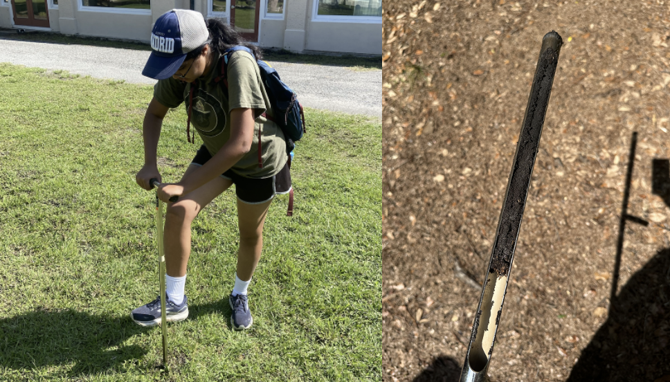
To test the samples, I used a soil core sampler to take A horizon soil at four-to-eight-inch depth (Figure 2), then used the Munsell book to identify color and a ribbon test and solution to identify texture. I held the soil samples to the Munsell book in direct sunlight in the field, then checked my color assessments twice under both fluorescent light and sunlight to ensure accuracy. For the ribbon test, I attempted to form a ball with slightly damp soil, then attempted to form a ribbon by pressing the soil with my thumb. If a ribbon formed, then I measured the length before breakage. I repeated this process 3 times to reduce errors. I also dissolved the samples in water, which revealed various layers of sediment and suspended clays that I may have missed in the ribbon tests.
Figure 2.A (left). Taking soil core measurements in the UGA Marine Institute courtyard
Figure 2.B (right). A soil core sample from the forest location
I also measured the nitrate content and pH of the topsoil in each location (Figure 3). To do this, I dissolved the samples 20mL of deionized water for every 10mL of soil. I measured pH with a Fisher Scientific pH meter and cross referenced my results with paper test strips. After removing the probe from the buffer solution, I would dip it into the solution until the meter stabilized, then rinsed it with distilled water before repeating the procedure for the next sample. Measuring nitrate required a testing kit and indicator reagent. After the samples settled, I added 5mL of each solution into the test tube, then added the indicator reagent. The reagent caused the solution to turn orange if it detected nitrate. I took these measurements once and put the results in bar graphs.
Figure 3.A (left): Nitrate testing apparatus
Figure 3.B (right): Dissolving soil samples in water for pH and nitrate tests
Results
There was very little deviation from the expected 10YR2/1 soil color in most places around the island (Table 1). This is a darker and duller variety of soil with a primarily yellow undertone. The most notable variations were the septic field (medium), dirt road, mansion and shell hammock (high). The septic field (medium) and dirt road (high) were significantly lighter in color, and the mansion (high) was slightly lighter. Shell Hammock (high) had a very close color to the rest of the soil on the island, but it had a redder hue.
The textures were mostly sandy, with grains on the finer side. There were varying amounts of silt in almost all of them, and some of them had clay. The septic tank was the sandiest, while the roadside and mansion had higher quantities of clay, along with the forest.
| Impact | Location | Color | Texture |
| Low | Forest | 10YR2/1 | Sandy Loam |
| Low | Overgrowth | 10YR2/2 | Sand |
| Medium | Pond | 10YR2/1 | Sand |
| Medium | Agricultural Field | 10YR2/1 | Sand |
| Medium | Septic Field | 10YR4/4 | Sand |
| High | Mansion | 10YR3/3 | Loamy Sand |
| High | Shell Hammock | 7.5YR3/1 | Sand |
| High | Courtyard | 10YR2/1 | Sandy Loam |
| High | Dirt Road | 10YR3/2 | Sand |
| High | Roadside | 10YR2/1 | Loamy Sand |
Table 1. Soil color and texture of each location, sorted by level of human impact.
The pH range was between 4.96 and 7.11 (Figure 4). As expected, most high impact areas have relatively higher pHs (in the 6 to 7 range), while the lower impact areas have more acidic ones (closer to 5). Most medium impact locations had pHs between 5 and 6, with the exception of the septic field at 6.42. The roadside pH was 4.96, far lower than the other high impact values.
Figure 4. Bar graph indicating pH in each location from low (green), medium (yellow), and high (red) impact.
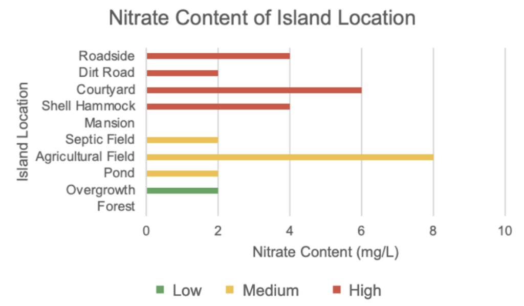
Nitrate levels ranged from 0 mg/L to 8 mg/L (Figure 5). The highest nitrate level was in the old agricultural field (medium) at 8 mg/L. The second highest were Shell Hammock and the roadside (high) at 4 mg/L. All other sites across impact levels had a nitrate level of 2 mg/L except for the mansion and forest, which had nitrate contents of 0 mg/L.
Figure 5. Bar graph indicating nitrate levels (mg/L) in each location from low (green), medium (yellow), and high (red) impact.
To compare both pH and nitrate in each site’s soil, I conducted a series of t-tests comparing the locations to each other (Table 2). None of the p-values were significant at a significance level of alpha = 0.1. However, according to these t-tests, the high v. medium categories had higher p-values than the other categories (pH: 0.505, nitrate: 0.702). These values could indicate that high and medium management sites were more similar to each other than high and medium sites were to low management sites. The p-values for low v. medium (0.148) and low v. high (0.135) indicate a possibility of finding significance using a 90% confidence level with more data, which invites further study.
| Low v Medium | Medium v High | Low v High | |
| pH | 0.148134794 | 0.504873004 | 0.134866435 |
| Nitrate | 0.345645839 | 0.702385741 | 0.272936261 |
Table 2. P-values from the two-sample t-tests run on pH and nitrate values.
Discussion
Analyzing the soil of Sapelo Island proved to be an interesting and complex endeavor. I only analyzed topsoil due to the severe soil compaction on the former dairy farm making it difficult to reach the B Horizon. Furthermore, it would take significant historical analysis and archival work to understand the previous land use impacts and how those affect the soil properties today. The agricultural and colonial history has definitely left an impact, and most likely interfered with the expected results (Chalmers 1997). I could not use the low impact areas as control variables because I was unsure what the history of the land included. Perhaps these areas were restored after farm use, or remain affected by the surrounding developments (Teal and Teal 1988). Because of this, the management practices aboveground are not always indicative of the earth below the surface. Future studies can account for this by cross referencing historical soil studies and descriptions.
The colors were very characteristic of the spodosols common to the island: dark and dull, indicating high organic content and frequent drainage. The four deviations from the expected result were all medium or high impact areas. Most of them were dark soils with only slight deviations that could be attributed to differences in organic and mineral content. More residential areas likely have less decomposition occurring on the soil, reducing the organic matter content. This is especially true for the dirt road, which is bare soil. The septic field had the most obvious difference in soil color; it was significantly lighter and brighter while still having the yellow undertone. That site is likely one of the few places that could tolerate a septic system, as soils need to be well drained in order to do so (Lee and Owen 2023). The pale, uniform color indicates a lack of organic matter, which can bind soil together and lead to tighter structure, and no gley.
Soil textures were primarily sandy. The quantities of silt and clay are most likely alluvium from the marsh, but another study measuring distance from the marsh and soil texture would confirm this. Interestingly, on the final day I found several slabs of clay on the beach, layered on top of the sand. While there was no time to examine these and include them in my study, this could be attributed to soil from a buried marsh on the north of the island. The island is likely shifting due to climate change and sea level rise, and this will affect the soil composition, leading to various anomalies on the island (Fagherazzi et al. 2019).
The pH of the soils, while insignificant, indicate the possibility of a trend with further study. The pH was the highest in the courtyard and the dirt road around the UGAMI institute. This is most likely because a decent pH for agriculture is around 6.5-7.5, and it seems like those sites have not had the time to readjust. Interestingly, the abandoned agricultural field had a lower pH, possibly indicating that the pH was reverting back to the average for spodosols after human management. The roadside pH was the lowest, most likely because of the runoff affecting the area. Further study is required to see how much this is affecting the plant communities and hydrology, although most organisms on the island would already be used to the general acidity of spodosols. The septic field had a pH of 6.42, ideal for microorganisms to function which is unsurprising (Lee and Owen 2023). The forest and overgrowth had pH values close to 5, which is not unusual for spodosols. There is evidence that if left untouched, other soils on the island will start moving towards these values.
The nitrate levels seemed to have very little correlation with management practices during statistical analysis. The p-values when comparing the areas of impact were much higher than the ones for the pH t-tests. However, there is evidence of the predicted trend, as the old agricultural field had the highest quantity, and the forest had the lowest. Perhaps the most shocking result that indicates a design flaw was the mansion nitrate levels being 0 mg/L. It is difficult for an area treated with pesticides and fertilizers to have a low nitrate content, let alone no nitrate at all (Abdelfattah et al. 2021). The mansion sample also had a high amount of clay and suspended solids, so it was difficult to get a clear and accurate reading. Despite waiting for two days, some solutions higher in clay content did not fully settle, so the suspended particles made it difficult to evaluate any changes in color (Figure 3.B). Additionally, perception of color is subjective, and I did not make enough solution for my samples or have enough time to perform multiple tests. The sandier soils should have more accurate results, but the samples with higher clay quantities most likely have inaccurate data. In future studies, it would be wise to centrifuge the samples to ensure better clarity of the solutions. This should drastically improve the nitrate readings and increase the chances of accurately identifying trends.
It is possible that the high and medium impact locations on the island have more in common with each other than with low impact ones. However, it is important to consider that this study was conducted with a narrow number of samples. Perhaps with more data, further experimentation, and refinement of the methods, we could find that comparing high and medium impact areas to low impact ones is indeed significant.
With more time, I would be able to expand this study to more areas of the island, gather multiple samples from various locations, and get more accurate test results for the nitrate and pH. Developing another categorization for human impacts would also improve the results. The high to low scale only investigates the level of impact and not the type, which proved ineffective since I was unable to use a proper control group. The type of impact would help dictate the direction of change that I predict (i.e., more or less acidic, darker or lighter soil).
Additionally, I would include distance from the various ecosystems on the island as a factor for my soil tests, because the marsh could also have an impact on the other soils of the island due to the high rates of decomposition and gleyed silty clay contrasting with the sandy spodosols found elsewhere (Zhang et al. 2024). It is also important to account for proximity to other test sites as well; the mansion sampling location was very close to the forest trailhead and overgrowth area, so the recovery in those places may have worked to return the mansion soils to their original form faster than other areas.
Investigating the impact of management on soil provides vital information for agriculture, urban development, ecology, and environmental health. Studies on Sapelo are also of significance to the Gullah-Geechee nation, the island’s residents who hold an important relationship to the land. I hope that future studies on this topic benefit their efforts in protecting their home from erosion and sea level rise and provide scientific knowledge towards cultural prosperity.
Conclusion
This study did not take into account all the factors influencing Sapelo Island, but suggests that the agricultural history of the island affects the land to this day. Both the results and the difficulties in gathering more data highlights how it is important to be mindful of land use practices, as they can impact the land for over seventy years in the future.
References
Abdelfattah, M. A., Rady, M. M., Belal, H. E. E., Belal, E. E., Al-Qthanin, R., Al-Yasi, H. M., & Ali, E. F. (2021). Revitalizing fertility of nutrient-deficient virgin sandy soil using leguminous Biocompost boosts Phaseolus vulgaris performance. Plants, 10(8), 1637. https://doi.org/10.3390/plants10081637
Chalmers, A. G. (1997). The ecology of the Sapelo Island National Estuarine Research Reserve. Sapelo Island National Estuarian Research Reserve. https://www.sapelonerr.org/wp-content/uploads/2013/08/Ecology-of-the-Sapelo-Island-National-Estuarine-Research-Reserve.pdf
Fagherazzi, S., Anisfeld, S. C., Blum, L. K., Long, E. V., Feagin, R. A., Fernandes, A., Kearney, W. S., & Williams, K. (2019). Sea level rise and the dynamics of the marsh-upland boundary. Frontiers. https://www.frontiersin.org/articles/10.3389/fenvs.2019.00025/full
Lee, B., & Owen, P. (2023). Septic drain field design and maintenance. SERA17 Phosphorus Conservation Practices Fact Sheets. https://sera17.wordpress.ncsu.edu/septic-drain-field-design-and-maintenance/
Natural resources conservation service. (2022). Spodosols. https://www.nrcs.usda.gov/conservation-basics/natural-resource-concerns/soils/spodosol
Teal, J., & Teal, M. (1988). Life and death of the Salt Marsh. Ballantine Books.
United States Department of Agriculture. (2023). Web soil survey. https://websoilsurvey.nrcs.usda.gov/app/WebSoilSurvey.aspx
Zhang, Y., Hartemink, A. E., Vanwalleghem, T., Bonfatti, B. R., & Moen, S. (2024). Climate and land use changes explain variation in the A horizon and soil thickness in the United States. Nature News. https://www.nature.com/articles/s43247-024-01299-6
Acknowledgements: I would like to thank Dr. Pucko, for her assistance and guidance with the project, my Sapelo Island classmates for their support with my experiment, and my professors and teaching assistants at the Odum School of Ecology and the Warnell School of Forestry for nurturing my interest and helping me develop the skills I need to complete this project.
Citation Style: APA


